View Larger Map
Sunday, 30 January 2011
Localization The Rodna Mountains National Park Romania


Location 47°40'N; 23°00'E
Area (hectares) 46,399
Core area(s) 8,200
Buffer zone(s) 11,800
Transition area(s) when given 24,000
Altitude (metres above sea level) +900 to +2,303
Wednesday, 26 January 2011
Puszcza Kampinoska - KAMPINOS FOREST - Poland
Geographical location:
52°14' to 52°26'N;
20°12' to 20°57'E

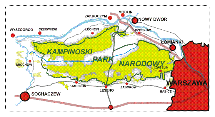
Puszcza Kampinoska is located in the European lowlands in the north-east of Warsaw and parallel to the valley of the Wisła River. This biosphere reserve is characterized by a high diversity of lowland habitats with dune belts separated by swamp areas and a mixture of forest types.
DOGA COLLEGE FOREST


Beykoz Doga Campus is situated on fifty hectares of Ahmet Mithat Efendi’s farm, which has been in use for 150 years in the north-west of Turkey, in İstanbul. Doga transformed this beautiful environment into a valley of education. The Doga educational system is based on a concept of natural education, and the Beykoz Doga Campus offers ample opportunities for students to discover and develop their abilities in a natural atmosphere. From it’s horse-riding facilities to it’s zoo, and from trekking courses to camping grounds, the natural environment of Beykoz Campus provides students from both the Beykoz Campus and other Doga Campuses with the opportunity to experience nature-based education.
Sunday, 23 January 2011
Studying the Maltese Forest
Studying the Maltese Forest.
Since the only forest in Malta is Buskett, we studied an area from this forest. Here we are describing our work. An area of around 50m by 50m was chosen. The criteria of selection were:
to chose an area that is not cultivated by man and that grows wild
that is safe to study i.e. no one can fall from high levels, there are no wells, no one can get lost
where there is species richness and not bare land.
The students were grouped in 3s or 4s and every group had to study 10m by 10m.
Quadrat method was used to sample and study the area. The following instructions were given to the students.
Calculating the species diversity using quadrats.
Aim: To analyse the species diversity in a particular area at Buskett.
Apparatus: quadrat, foreceps, writing material, measuring tape, string.
Method:
1. Find a suitable area at Buskett where the analysis could be carried out.
2. Measure the area.
3. Mark the area to be studied by placing a string at the perimeter.
4. Draw a map of the area to be studied.
5. Throw the quadrat over the shoulder without looking at where the quadrat will fall. Make sure that it doesn’t fall out of the marked area. If it does, pick it up and throw it again.
6. Move closer to the quadrat and analyse all the living organisms that you see inside. Take note of any vegetation, snails, insects, worms, etc.
7. Repeat steps 4 and 6 10 times. Try to cover all the area.
8. Analyse the results.
Results: draw a map of the area and indicate in which part was each quadrat thrown.
Conclusions:
What is the species diversity? (total number of different organisms found)
_______________________________________________________
Which were the organisms found?
______________________________________________________
_______________________________________________________
Which biotic component is most abundant?
_______________________________________________________
Which biotic component is least abundant?
_______________________________________________________
How were organisms distributed? (e.g. was there an organism found more in the shade, or in the sun, or near stones, or near a tree, etc)
Monday, 17 January 2011
LEIRIA'S PINE WOOD - where to find it!
This first map shows you where our forests is located - quite close to the Ocean shore.

See it closer…

 And closer…
Leiria’s Pinewood occupies about 11000ha of land.
It is located on the southern limit of a long littoral area of dunes covered with pine trees.
It’s geographical co-ordinates are 39º 42’45’’N and 39º 53´N of latitude and 8º03’30’’W e 9º03’’W of longitude. The climate is Mediterranean and wet.It starts close to the mouth of river Liz and lengthens along littoral coast to south.
JANUARY PHOTO FRAGAS EUME. IES AS TELLEIRAS

As you can see from this photo, the river is mostly very calm. The forest canyon.
This is our photo of January.
We hope that you enjoy it
GEOGRAPHY NOTES FRAGAS DO EUME. IES AS TELLEIRAS
My pupils made a description of the geography of the nature park Fragas do Eume.
This space - of something more than 9000 hectares -, comprises of the river basin of the Eume river, being able to define the great majority of its land like of average mountain, and characterizing its landscape by a strong intervention of the man.
This space - of something more than 9000 hectares -, comprises of the river basin of the Eume river, being able to define the great majority of its land like of average mountain, and characterizing its landscape by a strong intervention of the man.
Subscribe to:
Posts (Atom)